ScenarioManager
The ScenarioManager is our new data tool that calculates the effects of new spatial plans, such as cycle routes, residential or work locations.
De ScenarioManager is onze web-oplossing die helpt bij het beoordelen van nieuwe ruimtelijke plannen. Denk bijvoorbeeld aan nieuwe fietsroutes of nieuwe woon- of werklocaties. De tool brengt in kaart wat de effecten hiervan zijn voor mobiliteit en bereikbaarheid.
The mobility transition and accessibility pose a major challenge for municipalities, regions and provinces. Governments have to deal with multiple interests: the housing construction challenge, growing mobility and the desire to keep cities accessible and liveable. This means that difficult choices have to be made with a view to the future.
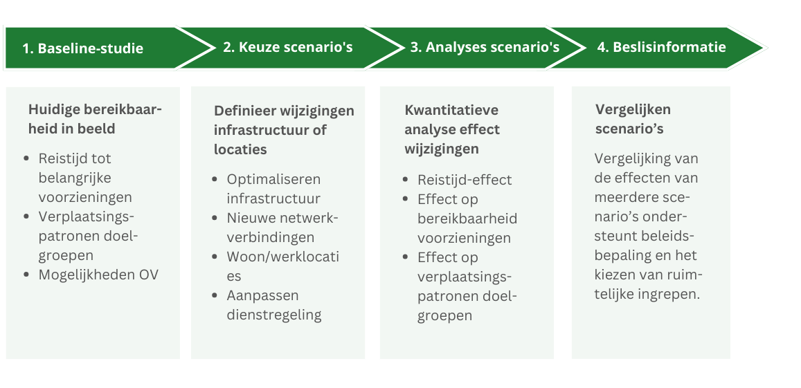
Daarom is het waardevol is om data-analyse in te zetten bij het beoordelen van ruimtelijke plannen. Dat geeft een beeld van de situatie nadat een bepaald (beleids-)plan zou zijn doorgevoerd. Door meerdere ‘wat-als’-scenario’s uit te werken, kan een overheid het effect van verschillende plannen toetsen. Daarmee krijgt men inzicht in de effecten voor de bereikbaarheid van gebieden en voorzieningen en de gevolgen voor specifieke doelgroepen.

The ScenarioManager: understanding the effects of adjustments to the transport network.
De ScenarioManager onderzoekt de effecten van aanpassingen aan het verkeersnetwerk of de OV-dienstregeling op bereikbaarheid en verplaatsingspatronen en. Denk aan de gevolgen van nieuwe woon- of werklocaties, nieuwe verbindingen, nog aan te leggen infrastructuur, alternatieve routes, sluitingen, de aanleg van bruggen of tunnels, etc. De ScenarioManager geeft direct kwantitatieve analyses terug over reistijd, de bereikbaarheid van voorzieningen en doelgroepen.
De ScenarioManager kan ingezet worden voor OV, auto, fiets, voetganger, multimodale reizen en vrachtlogistiek. Het kan bovendien mogelijk de effecten per doelgroep uitsplitsen.
What is possible with the ScenarioManager?
- Testing the effects of new connections and infrastructure
- Calculate the effects of new residential locations
- Calculating future accessibility
- Varianten vergelijken
- Substantiate policy choices
- Assess investments
Easily accessible
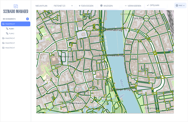
The ScenarioManager is interactive, flexible and accessible. As a user you do not need specific expertise. In a playful manner, you can develop an infinite number of future variants within a project. You do this by adding, removing or adjusting segments on the network on the map itself.
Effecst on accessibility immediately become visible through a series of maps, charts and tables. By doing so, the tool delivers quick insights into the accessibility of locations. This helps in shaping spatial plans and ultimately justifying policy.

Kom de ScenarioManager testen op het Fietscongres 2025!
We zijn verheugd dat we aanwezig zijn op het Nationaal Fietscongres in Amersfoort! Dit is bovendien een speciale gelegenheid: je kunt langskomen bij onze stand om de ScenarioManager uit te proberen. We maken graag kennis. Tot 21 en 22 mei!
Get in touch
Questions about our products and services? Or would you like to know more about the StraTopo company? Schedule a meeting with founder Sven Reulen directly in the calendar on the right or use our contact form to get in touch with us. We would like to hear from you!


