ROUTING ENGINE
Integration in Stantec's LocatieManager
Stantec has integrated StraTopo's Routing Engine into its LocationManager. The API provides data about accessibility levels and travel times. This enables area developers to determine the most promising development locations.
Application in LocatieManager
StraTopo’s partner Stantec is an international engineering firm that has been providing services in the Netherlands in the areas of the environment, soil, infrastructure, safety and energy for more than 40 years. One of Stantec's products for area developers is the LocatieManager: an online portal in which spatial information and smart tooling are brought together to map promising development locations.
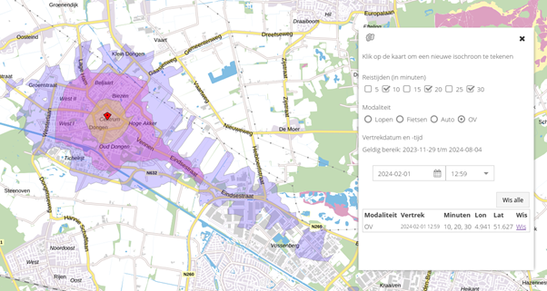
To allow users of the LocationManager to search more specifically for suitable plots, StraTopo has integrated our routing engine into the online tool. By choosing a travel time, and walking, cycling or car as the modality, travel time contours are generated that visualize how far one can travel from a chosen plot in a certain time.
As of 2024, Stratopo will offer new functionality in the routing engine, specifically aimed at public transport. For example, based on the timetables of national and regional transport companies and the road network, area developers can now gain insight into how much better or worse locations are accessible by public transport compared to by car.

Functionalities
- Route planner
- Isochrones
- Travel time
- Travel modes: vehicle, bicycle, pedestrian and public transport.
- Isochrone intervals: 5, 10, 15, 20, 25 and 30 minutes
Links
>> Stantec

