Flowbility
Flowbiliteit is het analyseplatform van StraTopo voor beleidsmakers en adviseurs die keuzes willen maken op basis van inzicht in bereikbaarheid. Het platform laat zien wat ruimtelijke en mobiliteitsmaatregelen doen met verplaatsingen en bereikbaarheid.
Niet achteraf verklaren, maar vooraf begrijpen.
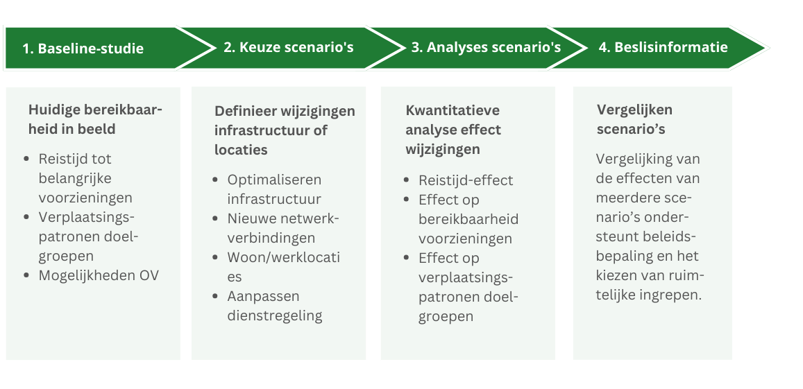
Flowbiliteit is het platform van StraTopo waarmee beleidsmakers en adviseurs bereikbaarheidsberekeningen uitvoeren en razendsnel meerdere scenario’s doorrekenen. Zo krijg je inzicht in de effecten van ruimtelijke en mobiliteitskeuzes vóórdat besluiten worden genomen.
Ontwikkeld door data-experts en technici
Flowbiliteit is gebouwd door de data-experts en technici van StraTopo. Zij ontwikkelen en onderhouden onze netwerken en rekenmethodes zelf. Daardoor hebben we volledige controle over:
hoe netwerken worden opgebouwd,
welke aannames worden gebruikt,
en hoe analyses worden geoptimaliseerd voor specifieke beleidsvragen.
Er zijn onder andere AI-gebaseerde netwerken beschikbaar in Flowbiliteit die gebaseerd zijn op bestaande verplaatsingspatronen.
Gebouwd op praktijk, geschikt voor beleid
Flowbiliteit is ontwikkeld vanuit concrete projecten . De analyses sluiten aan op echte uitdagingen. Daardoor zijn de uitkomsten:
realistisch,
transparant,
en bruikbaar in beleidsvorming en advies.
Het platform ondersteunt gesprekken tussen beleidsmakers, adviseurs en bestuurders met dezelfde, gedeelde inzichten.
Zien hoe dit werkt voor jouw vraagstuk?
In een demo laten we zien hoe Flowbiliteit wordt ingezet bij echte beleidsvragen.
Beleidsvragen doorrekenen in scenario’s
Met Flowbiliteit vertaal je beleidsvoornemens direct naar scenario’s. Je onderzoekt bijvoorbeeld:
hoe fietsgerichte stadsontwikkeling de bereikbaarheid verandert,
wat wegwerkzaamheden betekenen voor dagelijkse verplaatsingen,
welke rol mobiliteitshubs spelen in een gebied,
of hoe aanpassingen rond scholen doorwerken in het netwerk.
Scenario’s zijn eenvoudig aan te passen en onderling vergelijkbaar, zodat verschillen zichtbaar worden en keuzes uitlegbaar blijven.

Flowbility: exploring the effects of adjustments
Flowbility examines the effects of adjustments to the road network or public transport timetable on accessibility and movement patterns. Think of the impact of new residential or work locations, new connections, planned infrastructure, alternative routes, closures, or the construction of bridges or tunnels. Flowbility immediately provides quantitative analyses of travel time, the accessibility of facilities, and target groups.
Flowbility can be used for public transport, car, bicycle, pedestrian, multimodal travel, and freight logistics. It can also break down the effects by target group.
Easily accessible
Flowbility is interactive, flexible, and easy to use. As a user, you don’t need any specific expertise. By experimenting, you can develop countless future variants within a project. You do this by adding, removing, or modifying segments on the network directly on the map.
Effecst on accessibility immediately become visible through a series of maps, charts and tables. By doing so, the tool delivers quick insights into the accessibility of locations. This helps in shaping spatial plans and ultimately justifying policy.


